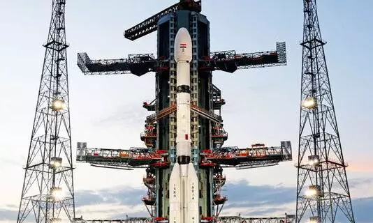
NISAR is expected to fly on a GSLV-F16 rocket at 5.40 pm from the second launch pad at the spaceport in Sriharikota situated about 135 km from Chennai on Wednesday (July 30). Photo: PTI
ISRO to launch collaborative NISAR earth observation satellite today
Jointly developed with NASA, the 2,393 kg NISAR satellite will use dual-frequency SAR to study global land and ice changes for five years

Aimed at boosting ties between India and the United States on space exploration, India is geared up to launch an earth observation satellite jointly developed by ISRO and NASA on Wednesday (July 30).
Eyeing to study the planet Earth as a whole from a Sun-synchronous Orbit, the NISAR satellite is a combination of human skills and exchange of software and hardware between the two space agencies for over a decade.
NISAR, an acronym for NASA-ISRO Synthetic Aperture Radar satellite, weighing 2,393 kg, is expected to fly on a 51.7 metre tall, three stage, GSLV-F16 rocket at a prefixed time of 5.40 pm from the second launch pad at the spaceport in Sriharikota situated about 135 km from Chennai on Wednesday.
Countdown began on July 29
The countdown for the launch commenced at 2.10 pm on July 29 and has been progressing, ISRO said, and the mission would be classified into launch phase, deployment phase, commissioning phase and science phase.
"GSLV-F16/NISAR. Today’s the day! Launch Day has arrived for GSLV-F16 and NISAR. GSLV-F16 is standing tall on the launch pad. NISAR is ready. Liftoff today," ISRO said in a social media post on Wednesday.
Also Read: Earth observation NISAR satellite to be launched on Jul 30: ISRO chief
While the partnership between ISRO and NASA is the first of its kind, it is also the first time for a GSLV rocket to carry a rocket destined to Sun-synchronous Polar Orbit (SSPO) unlike Polar Satellite Launch Vehicles.
NISAR to study the Earth
The Bengaluru-headquartered ISRO has sent similar missions in the past (Resourcesat, RISAT) to study the Earth but were "operationally-focused" on Indian territory. The NISAR mission is targeted to study the Earth and would provide information to the global scientific fraternity, ISRO said.
The satellite would be able to study seasonal changes on forest dynamics, mountain shifts, glacier movements in the Himalayas and Antarctica, North and South poles.
Also Read: India needs to triple satellites in orbit in next 3 years, says ISRO chief
NISAR mission's primary objectives are to study land and ice deformation, land ecosystems, and oceanic regions in areas of common interest to the United States and Indian science communities.
Developed over the last 10 years
ISRO said the complex payloads and mainframe systems in the mission have been designed, developed, and realised over a period of 8 to 10 years.
Scientists from both space agencies were involved in extensive collaborations and the NISAR satellite carries dual frequency - two L Band provided by NASA and S-Band provided by ISRO for the Synthetic Aperture Radar (SAR) enabling the collection of a vast amount of data.
The S-Band SAR and L-Band SAR were independently developed, integrated, and tested at ISRO and Jet Propulsion Laboratory, NASA, United States, respectively, ISRO said.
Also Read: ISRO's big missions for 2025: Space station, NavIC, and more
After reaching the initial orbital conditions on Wednesday, scientists would engage in “commissioning” the satellite.
The first 90 days after launch would be dedicated to commissioning or to perform In-Orbit Checkout, the objective of which is to prepare the observatory for science operations, ISRO said.
The dual-band Synthetic Aperture Radar employs an advanced, SweepSAR technique, which provides high resolution and large swath imagery. NISAR would image the global land and ice-covered surfaces, including islands, sea-ice and oceans, every 12 days.
102nd launch from Sriharikota
The spacecraft and the launch system are developed by ISRO while the L-band Radar system, high-speed downlink system, GPS receiver are delivered by NASA. ISRO is responsible for the satellite and commanding operations, while NASA would provide the orbit manoeuvre and RADAR operations plan.
NISAR mission would be aided with ground station support of both the space agencies for downloading the acquired images, which, after the necessary processing, would be disseminated to the user community.
Also Read: NASA, ISRO to launch joint space mission to map globe every 12 days
GSLV-F16 is the 18th flight of Geosynchronous Satellite Launch Vehicle and the 12th with indigenous cryogenic stage. It is also the 102nd launch from Sriharikota.
The life of the NISAR Mission is 5 years, ISRO said.
(With inputs from agencies)

