
- Home
- India
- World
- Premium
- THE FEDERAL SPECIAL
- Analysis
- States
- Perspective
- Videos
- Sports
- Education
- Entertainment
- Elections
- Features
- Health
- Business
- Series
- In memoriam: Sheikh Mujibur Rahman
- Bishnoi's Men
- NEET TANGLE
- Economy Series
- Earth Day
- Kashmir’s Frozen Turbulence
- India@75
- The legend of Ramjanmabhoomi
- Liberalisation@30
- How to tame a dragon
- Celebrating biodiversity
- Farm Matters
- 50 days of solitude
- Bringing Migrants Home
- Budget 2020
- Jharkhand Votes
- The Federal Investigates
- The Federal Impact
- Vanishing Sand
- Gandhi @ 150
- Andhra Today
- Field report
- Operation Gulmarg
- Pandemic @1 Mn in India
- The Federal Year-End
- The Zero Year
- Science
- Brand studio
- Newsletter
- Elections 2024
- Events
- Home
- IndiaIndia
- World
- Analysis
- StatesStates
- PerspectivePerspective
- VideosVideos
- Sports
- Education
- Entertainment
- ElectionsElections
- Features
- Health
- BusinessBusiness
- Premium
- Loading...
Premium - Events
How historic Kaveripoompattinam port town was digitally mapped and what it revealed about ancient trade routes
While a fresh underwater archaeological exploration of the ancient city — also known as Poompuhar — is currently underway, a digital mapping of the area started in 2023 had relied on then available findings and references to Kaveripoompattinam in early literary texts

The historic city of Kaveripoompattinam, also known as Poompuhar, is recognised as one of the prominent ports of ancient India, having been active during the early centuries of the Common Era (CE). Literary sources suggest that the ancient city faced destruction owing to marine incursions or natural disasters, although the exact nature of these events remains unclear. Some historians also...
The historic city of Kaveripoompattinam, also known as Poompuhar, is recognised as one of the prominent ports of ancient India, having been active during the early centuries of the Common Era (CE). Literary sources suggest that the ancient city faced destruction owing to marine incursions or natural disasters, although the exact nature of these events remains unclear. Some historians also believe that Kaveripoompattinam underwent multiple relocations and reconstructions because of frequent natural disasters, including sea surges, floods, and cyclones. According to them, the port, located in today’s Mayiladuthurai district of Tamil Nadu, might have been submerged either as a result of of these calamities or owing to marine incursions, approximately 1,000 years ago.
Archaeological excavations and underwater explorations have revealed some remnants of the ancient city, but though a few potential structures and a shipwreck from the colonial period have been investigated underwater, the remains of Kaveripoompattinam have not yet been fully excavated. In recent years, based on ocean bathymetry data from the General Bathymetric Chart of the Oceans (GEBCO) and theories regarding ancient sea level changes, several geologists have suggested the possibility that the port existed further east beneath the sea than initially believed. Bathymetry is the study of the sea bed and water depth.
Also read: Osmania biscuit: How Hyderabad’s popular tea-time snack got the Nizam’s name
The cultural activities associated with the port, which were linked to the Indian Ocean regions, Buddhism, and the Chola kingdom, have been recorded in ancient Tamil texts such as Pattinappalai and other Sangam works — early classical Tamil literature — as well as in the medieval texts of Cilappatikaram and Manimekalai. Historians say that the written sources provide insights into the ancient city's character, its different neighborhoods, and its trade activities. However, the underwater digs and other research done so far haven't quite painted a full picture of the port city, especially regarding the parts that remain underwater.
Last week, the Tamil Nadu State Department of Archaeology (TNSDA), in association with the Indian Maritime University, again commenced underwater archaeological explorations in Kaveripoompattinam. Scholars are of the opinion that the 10-day excavation will provide greater insight into the significance of Kaveripoompattinam as a prosperous port city.
However, in 2023, a team comprising an earth scientist, an epigraphist and two archaeologists had already started mapping the area using geo-spatial technology — an advanced method which uses global positioning system (GPS), geographic information system (GIS) and remote sensing to collect, visualise and analyse the geographic data. The correlation between the then available archaeological findings and ancient literary texts facilitated the mapping of various known structures within the vicinity of the ancient city.
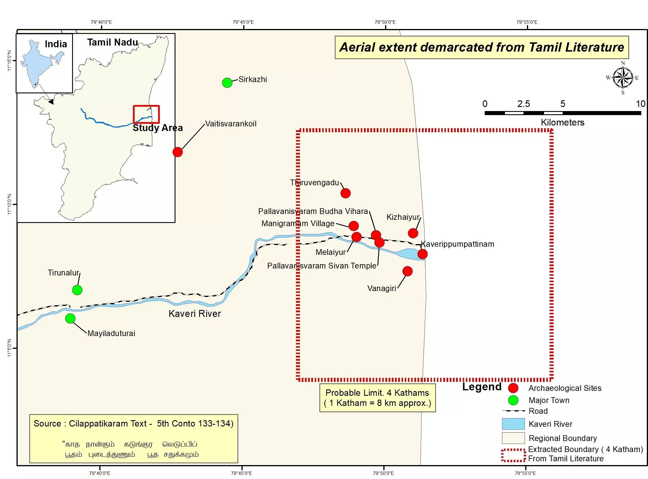
Estimated extent of the Kaveripoompattinam. By special arrangement
“We documented the trade route based on toponymical (place names) study, historical data and archaeological materials using GIS. A field survey was conducted in the region and the excavated and explored archaeological sites were identified along the trade routes,” earth scientist R Neelakantan, who heads the department of industries and earth sciences, Tamil University, Thanjavur, and was part of the mapping team, told The Federal. He added: “The village names and historical place names and the topographical contexts were studied using maps and published texts. GPS points of the settlement sites were documented. We visited the excavated sites of Pallavanisvaram, Kizhaiyur, Tarangampadi and Vanagiri and travelled along the contemporary routes to have a first-hand experience of the ancient trade ways.”
Being a significant port in the Cauvery delta along India’s eastern coastline, Kaveripoompattinam thrived during the early historic period from 300 BCE to 500 CE. Situated near the confluence of the Cauvery river, it served as a vital urban center on India’s southeast coast and was linked to the early historic settlement networks of the Indian Ocean. The site has been associated with the Buddhist landscape stretching from eastern India to Sri Lanka through Andhra Desa (a historical region in India’s Deccan plateau, comprising the present states of Andhra Pradesh and Telangana and parts of the neighbouring states of Odisha, Karnataka and Maharashtra).
Also read: Samudaya at 50: Why Karnataka’s theatre collective must reinvent to stay relevant
The digital mapping of the archaeological remains linked to Kaveripoompattinam and the trade routes exemplified teamwork in every aspect, as the project, which relied on both archaeological and literary sources, required specialised knowledge in earth science, archaeology, and literary analysis. In addition to Neelakantan, the team comprised senior epigraphist S Rajavelu and archaeologists V Selvakumar and S Thamarai Kannan. They first explored the region and studied the textual and archaeological sources of the ancient city and its associated landscapes and trade routes. Based on the data that they received from the archaeological, literary and epigraphical sources, they mapped it using geo-spatial technology.
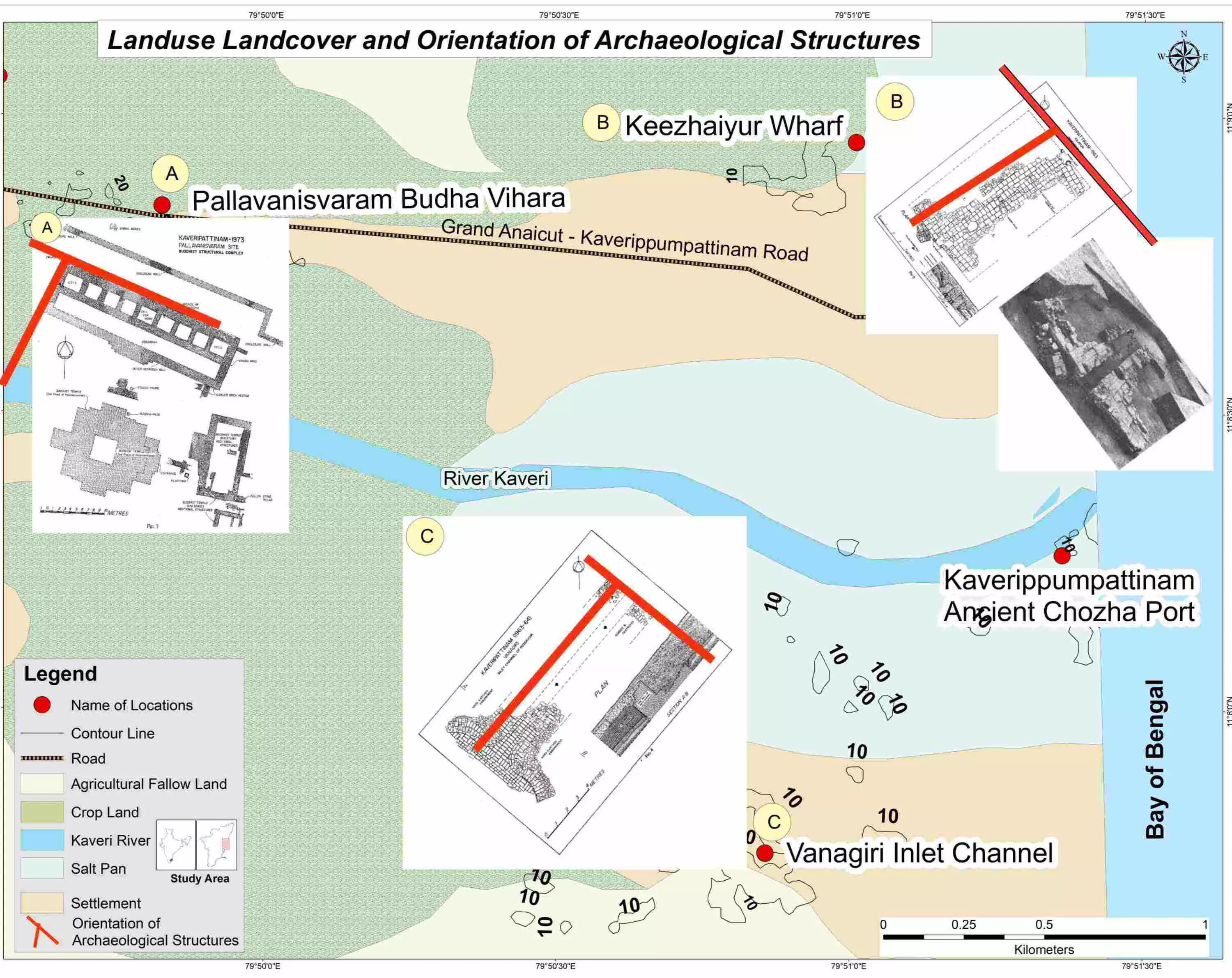
Important excavated structures onshore Kaveripoompattinam along with their orientation. By special arrangement
The technology, according to Neelakantan, helped them understand the geography and human activities of the region. “We found pilgrims, travellers and flower sellers on the stretch when we travelled along the route as part of this survey. It showed a continuous tradition in the region. With all the collected data, maps were prepared using GIS to understand the orientation of the structures and the cultural landscape, and to trace ancient trade routes,” he said. The survey also documented places of historical importance on the landscape between Kaveripoompattinam and Madurai.
Numerous existing textual sources provide insights into the characteristics of Kaveripoompattinam and its cultural and commercial endeavors. "Tamil literature, including works like Akananuru, Purananuru, Pattinappalai, Cilappatikaram, and Manimekalai, contains valuable information regarding Kaveripoompattinam. Texts like Milindapanha, the Jataka tales, Abhidhammavatara, and Buddhavamsatihakatha, as well as Greco-Roman writings, including the Periplus of the Erythraean Sea, Ptolemy's Geography, and Pliny’s accounts, contribute further information about the city, confirming its status as a port during early historical periods," said Selvakumar, who heads the department of maritime history and marine archaeology at Tamil University.
Also read: How Assam’s indigenous communities are fighting to revive endangered Tai languages
A significant narrative found in Cilappatikaram details the journey of the epic’s protagonists Kovalan and Kannaki, as they travel to Madurai, following their misfortunes in Kaveripoompattinam. “Utilising references from the work, alongside archaeological findings, the trade route has been delineated. Archaeological and historical sites pertinent to the journey of Kovalan and Kannaki have been cataloged, and potential routes have been charted using GIS software,” Selvakumar explained.
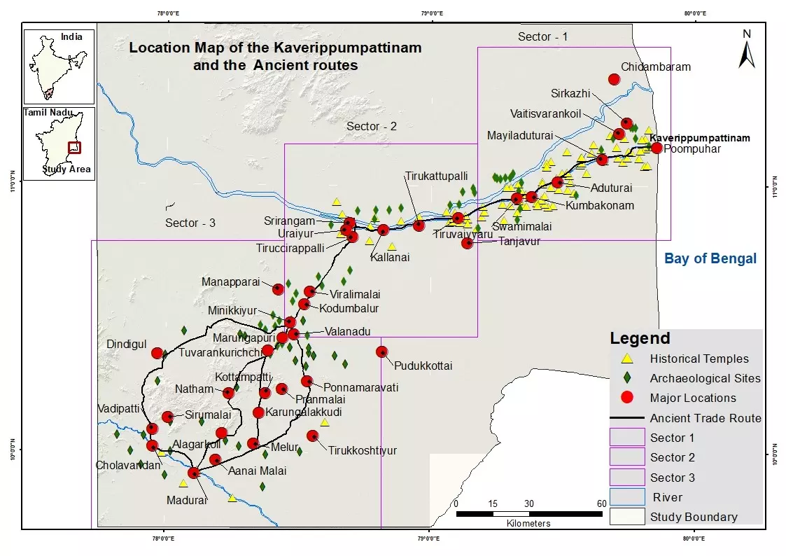
He added: “We traversed the primary trade route connecting Kaveripoompattinam and Madurai, spanning 275 km. The approach to identifying the settlements involved locating areas with archaeological sites and temples from the historical era. The map was created based on the latitude and longitude of these sites. Several significant locations are indicated on the maps.”

Ancient route from Kodumbalur to Madurai. By special arrangement
According to him, many of the principal settlements along the Kaveripoompattinam and Madurai route possess archaeological, art historical, and epigraphical documentation. “A notable site along the trade route is Tillaistanam. An inscription found in the Shiva temple of this village mentioned a highway known as Kongapperuvazhi. Kongu pertains to the western region of Tamil Nadu, encompassing Coimbatore, Karur, Erode, and Salem areas. Peruvazhi translates to highway or major trade route in Tamil. This highway linked Kaveripoompattinam with the Kongu region and the ancient port of Muciri or Muziris via the Chola capital of Uraiyur and the Chera capital of Karur,” he said.
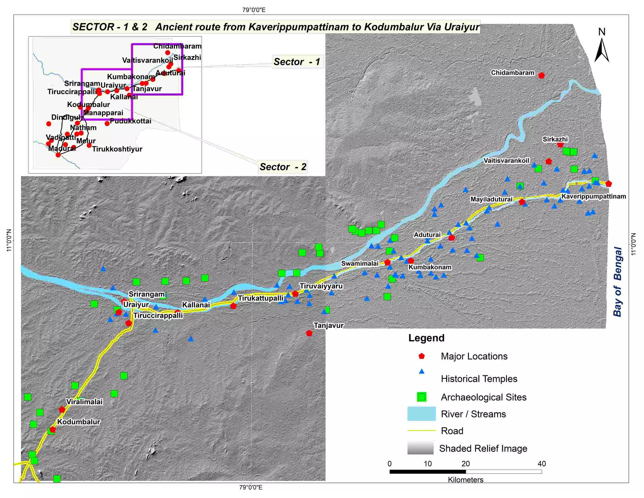
Ancient route from Kaveripoompattinam to Kodumbalur via Uraiyur. By special arrangement
It is believed Kaveripoompattinam and Uraiyur were prominent centers of Chola activity during the early historic period. Following a decline after 400 CE, the Cholas regained prominence in the mid-900 CE. During this medieval period, they emerged as a significant maritime political power in the Indian Ocean, launching political expeditions to Southeast Asia. Thanjavur became their political hub, while Nagapattinam served as their main port. By this time, Kaveripoompattinam had diminished to a small fishing village.
The mapping team studied references from Cilappatikaram and Pattinappalai and researched various trade routes and settlements of Kaveripoompattinam as part of their project. Pattinappalai, according to epigraphist Rajavelu, talks elaborately about the traded goods of Kaveripoompattinam such as the majestic horses that came through the sea, the black pepper bags that were carried by the animals, the gems and gold from the northern hills, the sandal and aloe from the western hills, the pearls from southern sea, the coral from the eastern sea, the goods from the Ganga and commodities from the Kaviri, food from Izham and produce from Kaazhagam.
“This shows the long-distance trade routes from the Malaysian region known as Kazhagam, the eastern sea near the Malacca straits, the areas of northern India, Bengal region, Coorg region and the western part of Tamil Nadu and Sri Lanka and the southern part of Tamil Nadu. These trade routes contributed to the wealth of Kaveripoompattinam. These references have helped to understand certain aspects of the ancient city and the associated settlements and trade routes,” said Rajavelu.
Also read: Kolhapuri Saaj: How this handcrafted gold necklace keeps a city’s heritage alive
Field, as well as underwater, archaeological surveys have been conducted in the past at the site of the ancient port of Kaveripoompattinam and its vicinity. “A team from the Archaeological Survey of India [ASI], led by SR Rao, KV Soundararajan, and KV Raman, had excavated the sites of Keezhaiyur, Pallavanisvaram, and Vanagiri, uncovering brick structures and various material remains. These archaeological remnants are largely fragmentary. The comprehensive layout of the city and the material described in the literature remain elusive,” said Rajavelu, who had previously been part of some significant excavations in the region.
At Kizhaiyur, a brick structure recognized as a wharf had been excavated by the ASI. At Pallavanisvaram, a Buddha Vihara and a Buddhist temple have been excavated, along with a bronze sculpture of the Buddha. At Vanagiri, a sluice structure has been unearthed. A repeated search unearthed ceramic, beads, animal bones, a Buddha Pada crafted from limestone, terracotta and various other artifacts. Radiocarbon dating conducted on a wooden post located near the wharf structure has dated one of the structures to approximately 300 BCE.
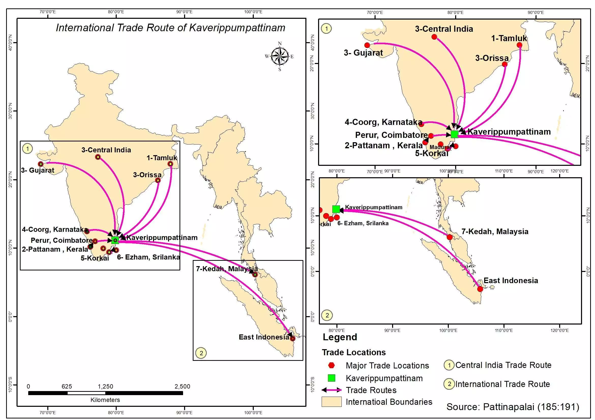
Trade routes interpreted from the references in the ancient Tamil text. By special arrangement
“Based on archaeological excavations, only a few brick structures have been identified in the outskirts of the city along the coastal region, while the core area of the ancient city is perhaps buried in underwater sediments, beyond the current coastline,” said Neelakantan.
He added: “It is observed that most of the buildings are in the orientation of northeast to southwest direction. The brick structures excavated are located near contemporary settlements and highways and are related to residential activities.”
According to Selvakumar, the orientation of the structures reveals that the ancient city of Kaveripoompattinam was perhaps “oriented 4-to-8 degrees to the east as indicated by the medieval temple of Tiruvengadu and the Buddha Vihara temple at Pallavanisvaram”. He added: “More research is necessary for identifying the core area of the ancient city”.
All eyes are now on the ongoing underwater archaeological exploration of Kaveripoompattinam by the TNSDA and Indian Maritime University, as experts await fresh finds to fill the gaps in the available knowledge about this ancient port city.
